
Rock Creek's sacrificial West Slope Cutthroats
Who wins when threatened Species at Risk Act (SARA) cutthroat trout are left to defend themselves and their spawning beds from bulldozers and backhoes?
By Monica Field and David McIntyre
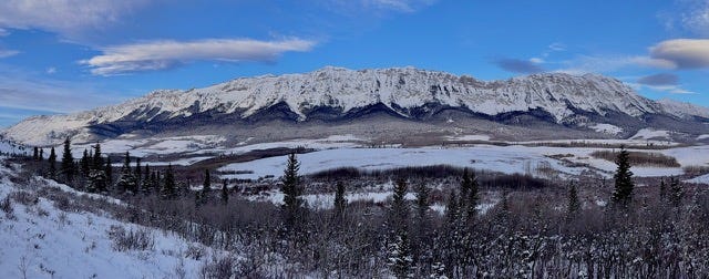
Looking west towards the Livingstone Range and into the headwaters of Rock Creek.
Painting the Picture
If you’ve driven west on Highway 3 past Lundbreck Falls, you may have stopped at the Burmis Tree (the skeletal remains of an ancient limber pine, Canada’s most photographed tree). Farther west, highway travellers are exposed to the arresting sight of Turtle Mountain’s fractured eastern face and the 1903 Frank Slide (North America’s most deadly rock avalanche). If you’ve seen these landmarks, you’ve also looked north to catch a glimpse of the serrated, cutting edge crest of the Livingstone Range.
Striking in profile, the Livingstone Range slices north into a cerulean sky. It’s heaven on earth for sailplane pilots who ride a river of wind with a chance to soar into the stratosphere. This same raging river, surging east across the crest of the range, is the migration-defining flyway for the world’s greatest concentration of golden eagles—more than 1,000 have been counted here in a single day.
Timberline on the ramparts of the Livingstone Range is cloaked in endangered limber and whitebark pines. Beneath them, there’s archaeological treasure including a 5,000 year-old chert mine and vision quest sites featuring revered power peaks: Chief Mountain (far to the south) and Crowsnest Mountain (towering above nearby Grassy Mountain).
Amid the magic of knife-edged rock and sweeping views, bighorn sheep grace the high country, grizzlies traverse the valleys, and native cutthroat trout cling to a small remnant of their former range in a handful of streams that flow south to feed the Crowsnest River.
Our home, overlooking Rock Creek on the eastern flanks of the Livingstone Range, is surrounded by an internationally marketed Crown of the Continent landscape and world-class beauty. But, overnight, the trout seen yesterday at our doorstep appear to have vanished. Dark clouds surround us.
Beauty and the Beast
Within this land of internationally recognized beauty lies a beast that lusts for ill-considered industrial projects. When highway planners say there’s a need to create a twinned superhighway through the doubly-designated, legislatively-protected cemetery known as the Frank Slide, there are people who embrace this vision and its willful destruction of Alberta’s once-proud heritage. When speculators want to remove mountains to mine the underlying coal, there are those who cheer. When overhead transmission lines and pipelines target this land of internationally acclaimed cultural and natural wonder, the promise of jobs draws support. Only a relative few, with tears in their eyes, stand in the shadows to watch as bulldozers and feller-bunchers level ancient forests.
Regulations are the best they claim
But that’s just how you play the game
On the ground it’s all the same
We’re losing
But I won’t play, I’ll show what’s lost
You’ll see the truth, you’ll learn the cost
Of the trade-offs that we’re choosing
(From I Won’t Play, a song by Monica Field)
We’ve long fought the brand of perceived progress that degrades and sometimes destroys priceless cultural and natural history features on the land we call home. We view these treasures as irreplaceable long-range assets that, if saved and protected, increase forever in value and sustain quality-of-life living.
The Stealth of a Cryptic Ad
We almost missed it. What we saw was a bland newspaper ad. A thin dark line on a pale and lifeless map accompanied a handful of archaic place names. It was only when we applied a virtual magnifying lens that we realized we were looking at a TC Energy ad for a monstrous, over-the-Livingstone-Range pipeline expansion, seven kilometres of buried pipe measuring 48 inches in diameter.
Our happenstance discovery of the ad six years ago, coupled with the realization that the forecast project, paralleling the creek on which we live, was to be built in 2023, prompted us, wide-eyed, to pursue TC Energy’s promised engagement with the impacted community. We had many concerns, but our primary concern was for the already threatened SARA-protected cutthroat trout that swam at our doorstep. We wrote to TC Energy, then contacted the company again when it failed to respond within its own, self-stipulated deadline.
We were ultimately assured, via a TC Energy videoconference, regular and ongoing meetings. The picture, initially promising, failed to take shape. Net result: no interaction occurred. We, in the dark, were forced to, again and again, recontact TC Energy to re-request promised meetings. Our requests were never honoured—this, throughout three long years.
Pipeline construction begins
There was never an open house for the project within the Municipal District (MD) of Pincher Creek, i.e., within the area surrounding TC Energy’s colossal Rock Creek worksite. As a result, pipeline construction began (2023) without, as far as we know, meaningful opportunity for public feedback or recommendations from area residents, including ourselves. (There was, after construction had started, a TC Energy open house in the Municipality of Crowsnest Pass, an event we were unable to attend. People who did attend told us the meeting was used to recruit pipeline workers.)
Today, among our many lingering concerns, we fail to understand how apparent Canada Energy Regulator (CER) approvals of TC Energy’s actions and/or non-actions allowed for what we believe was a complete failure by TC Energy to meet its stipulated requirement to consult with area residents most impacted by the project.
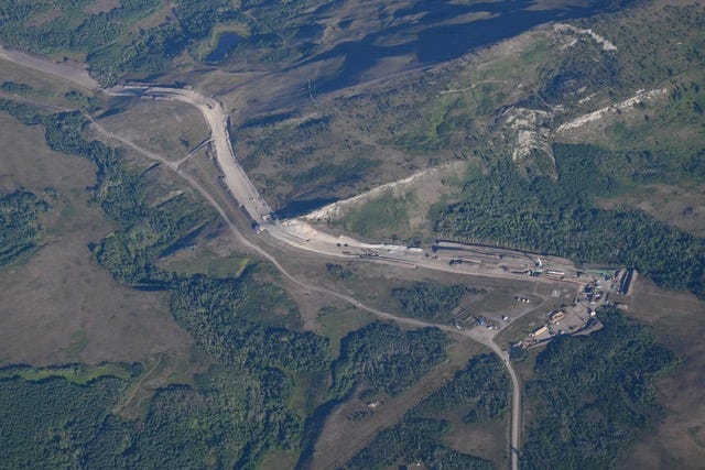
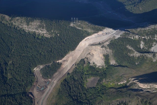
The view looks down on the TC Energy Rock Creek worksite at the eastern end of its 2023 pipeline construction traversing the Livingstone Range between Rock Creek and Gold Creek. The pictured pipeline, the dominant scar on the land, is paralleled by a heavily used TC Energy pipeline construction road. Located to the immediate left of this road is Rock Creek and its “critical habitat” (as defined by its ability to support cutthroat trout). Rock Creek, while not seen here, is defined by the serpentine stream-hugging forest that’s seen below—and then crossing—the TC Energy access road and pipeline.
Once the pipeline project was underway (spring into summer into autumn of 2023), area residents—particularly those living on the MD of Pincher Creek’s North Burmis Road—who were impacted by construction noise, clouds of dust, and road safety issues, voiced strong concerns. With trucks, work busses, and other intense industrial traffic dominating their daily lives, broader concerns took a back seat.
Missing from the discussion table once construction began: the pipeline’s route through rare and endangered forests; the fate of other rare plants; the loss of habitat for threatened wildlife species; and the impact of a ragged seven-kilometre clearcut bulldozed through iconic, world-class vistas and viewscapes.
There was no longer an opportunity—and for us one never existed—to address construction practices and their potential to impact the federally-designated critical habitat of Rock Creek’s threatened pure-strain cutthroats. We’d watched these trout for decades, always thrilled to see them emerge from crystal clear depths to grab tossed grasshoppers. During winter, after auguring a hole through creek ice, we’d lie face-down and watch as cutthroats congregated in spinning whorls of constant motion.
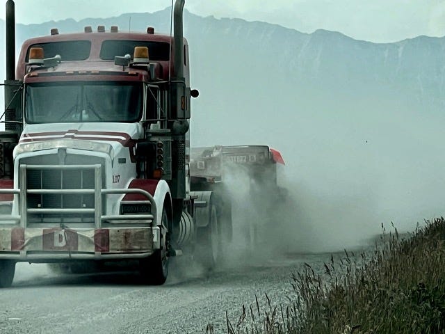
Intense truck traffic associated with construction of the TC Energy pipeline created colossal clouds of dust that obscured views and forced other users of the North Burmis Road to pull over and stop.
The “trout issue” was addressed during a pre-pipeline construction hearing, but it’s our understanding that fisheries biologists’ concerns addressing the likelihood of damage to the trout and their spawning beds were ignored. Regardless, the picture today looks bleak. Rock Creek’s native cutthroats appear to have been sacrificed. We haven’t seen, since mid-August of 2023, the trout we, for decades, saw daily.
Our observations suggest the SARA-protected native trout that have been a cherished part of our lives for more than thirty years may no longer exist, that SARA protection was meaningless. We don’t know this with scientific rigour, but we feel it in our hearts, and what we see is heartbreaking. We continue to look longingly into Rock Creek, but all we see is a blanket of life-choking sediment.
When TC Energy took de facto ownership of the pipeline’s over-the-Livingstone corridor, its workforce became, in effect, the only regular observer of actual on-the-land outcomes. The concerned public, effectively sidelined, knew only that the expanded right-of-way forest was being removed, that endangered whitebark pines and limber pines were among the dead.
Unknown to society today is the pipeline’s impact on ancient archaeological sites (including 5,000 year-old chert quarries), or on an internationally marketed National Geographic Geotourism raptor viewing site. Unknown, too, is the full extent of the post-construction impact on Rock Creek’s threatened cutthroats, their spawning beds and designated “critical habitat,” all supposedly protected, nurtured, and safeguarded throughout construction due to SARA guarantees.
It was more than three years ago when we, writing to the Municipal District (MD) of Pincher Creek Chief Administrative Officer (CAO), began to detail concerns and provide picture-supplemented photos of the North Burmis Road’s existing dust problem and its profound—into Rock Creek and into the Crowsnest River—downwind dust depositions. We had discovered windrows of shin-high road grit along Rock Creek hundreds of meters east of the North Burmis Road and felt action needed to be taken to protect the stream from wholesale, wind-deposited road dust sedimentation. Our messages contained shocking, stark, documentary images of windblown road grit.
Our multiple “dust” messages to the MD of Pincher Creek were sent long before and during construction in an effort—it failed!—to ensure work didn’t generate downwind dust to further degrade and diminish Rock Creek’s ability to support its already threatened trout. We also believed the MD of Pincher Creek could save money in road-surfacing costs by controlling the problem.
Fast-forward to the spring of 2023 when, at the onset of pipeline construction, dense clouds of road dust blew east from North Burmis Road to become an immediate health and safety issue as seen by area residents. The road surface failed to hold up under the intense industrial traffic and soon deteriorated to become rough, potholed, and dangerous.
These issues raised alarms and voices of concern. During this time, and while TC Energy denied there was a dust problem, we took pictures of intense, nearly horizontal dust storms as they, for hours on some days, raged west-to-east along the TC Energy pipeline right-of-way within, and across, critical habitat for the on-paper-protected cutthroats.
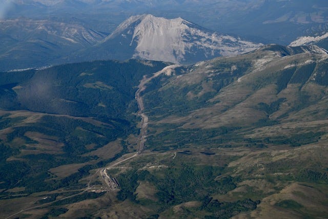
The TC Energy pipeline scar is seen here as it cuts through the headwaters of Rock Creek and crosses the Livingstone Range divide into the headwaters of Gold Creek to the west. Beyond the pipeline, the 1903 fractured face of Turtle Mountain reveals the scar left by North America’s deadliest rockslide, an event that claimed an estimated 100 lives.
When clouds of road dust engulfed and entered area homes, impacted hay crops, and threatened human health and safety, dust concerns commanded centre stage. Residents, upset, expressed their concerns to the MD of Pincher Creek, and spoke out against the colossal impact of pipeline construction work on their daily lives.
There was, without any acknowledgement of a dust problem, a sudden, overnight change in the application of dust-control measures. It occurred after local media coverage exposed the North Burmis Road situation (with issue-defining pictures) and residents’ health and safety concerns. But the late-July application of dust control measures was never, in our opinion, adequate and it was soon, seemingly, abandoned.
We felt the North Burmis Road, since that time, continued to worsen under intense truck traffic, that during October it was potholed, rutted, and dangerous to drive. Then rain turned it into a mud bath before cold weather returned to encase residents’ vehicles in frozen muck.
TC Energy’s mid-summer incident report—it was issued during a protracted multi-year drought—appears to suggest sediment barriers installed along the native trout stream’s critical habitat failed in a wholesale way, and did this when precipitation was far below normal.
The TC Energy over-the-Livingstone Range pipeline as seen during its 2023 construction. The view looks down on the crest of the Livingstone Range into the sunlit headwaters of Gold Creek. Rock Creek, to the east, lies in shadow. The turquoise sections of pipe in the foreground are 48” in diameter and measure up to 24 metres in length.
Our assessments of presumed-dead-and-missing cutthroats rely on visual observations. We’re aware, too, of ongoing concerns expressed by fisheries biologists, and an assertion the Department of Fisheries and Oceans (DFO) issued its SARA section 73 permit unlawfully. The claimants further assert that, regardless, the section 73 permit conditions have since been breached; the illegal issuance and/or breach renders the CER’s permit to NGTL (TC Energy) null and void; and the CER should have issued an immediate stop work order with a demand that TC Energy initiate remediation of the damaged habitat.
A burning question: Why did the CER allow TC Energy to excavate deep trenches across Rock Creek’s fragile headwaters despite the fact that fisheries biologists identified tunnelling under this designated critical habitat as the only safe way to proceed?
Did this deep trenching, coupled with the subsequent failure of sediment traps, enable copious quantities of waterborne sediment to enter Rock Creek? We don’t know.
Whatever happened during TC Energy’s mid-summer pipeline construction work on Rock Creek remains a mystery that appears to be wrapped in dark bureaucratic tape or hidden in work desks.
We know TC Energy has filed an “incident report.” What we comprehend on a much deeper and visceral level is that our current views of the once-sparkling, vibrant creek don’t reveal darting trout. Instead, they expose a stream bed choked in sediment.
We’ve spent a big part of the past four years in attempts to save Rock Creek from being subjected to the muddy mess that, today, would appear to imperil the lives of any remaining trout, a mess that continues to smother the stream’s once rich aquatic invertebrate life, food for these trout.
We look out at apparent death water as Rock Creek flows downstream to its confluence with the drought-degraded meagre flow of the Crowsnest River, an internationally renowned trout fishery.
The cumulative impacts of a pipeline traversing the headwaters of Rock Creek and, to the west, Gold Creek, coupled with a vast and undocumented network of unauthorized OHV “trails,” bleed sediment into both streams.
“Don’t worry,” industry proponents said. “Alberta and Canada have the best regulatory standards in the world.”
Do we? Don’t we have numerous glaring examples that illustrate, graphically, we don’t? Don’t we have examples that reveal how the monitoring of industrial activity, while documenting the accelerating diminishment of life or the ultimate death of monitored species, failed to result in any deviation in industrial activity?
We believe our effort to protect threatened cutthroat trout in the creek at our doorstep mirrors similar outcomes across Canada, and suggests there’s widespread failure of Canada’s Species at Risk Act to protect endangered species.
If government-stipulated worksite practices are deemed adequate, even if they don’t meet the rigour of obvious need, and SARA-protected cutthroat trout die in muddy trenches as a result, are these deaths newsworthy?
Humans do what humans can, but finite is the life of man
We can’t see beyond the span of our years
Don’t tell me we can have it all
While our children take the fall
They’ll tell us that we dropped the ball through their tears
(I Won’t Play)
Backstory
It’s our understanding that, following months of meetings in 2020, there were CER and DFO approvals that gave TC Energy permission to proceed with its over-the-Livingstone pipeline upgrade pending the Minister of Environment and Climate Change Canada’s endorsement.
This endorsement, with cabinet’s approval, allowed TC Energy to trench across the identified critical habitat for Rock Creek’s native cutthroats. In other words, Canada invested substantial time and colossal sums of money to achieve the results we see today a stone’s throw from our front door.
The picture today
As winter turns to spring, Rock Creek, at our doorstep, looks pristine and sparkling clear. But the cutthroats that swam here for 10,000 years—trout that revealed their presence through highly visible and active abundance for treasured decades—appear to have been extirpated by one pipeline’s expedited construction.
TC Energy has denied the validity of the pipeline construction concerns we have expressed. Countering this, we report that all our concerns are valid. We feel we’ve failed to accomplish anything that would benefit Canadians or mitigate the project’s impact on a priceless, world-class, internationally marketed (by National Geographic and others) Crown of the Continent landscape.
What is needed to create positive change? Effective project oversight by federal and provincial governments; rock-solid assurances that science-based, government-defined standards are adhered to by contractors; and meaningful public involvement in land-use planning.
Government and industry together with Society
In the end we all agree, pretending
What we want we want right now
Doesn’t really matter how
There’s no other value worth defending
(I Won’t Play)
The bottom line
Canada’s diverse population of caring and knowledgeable people expects—and deserves!—to have its voice heard and acted upon. This is especially true when massive industrial projects target world-class, internationally revered and tourism-marketed lands.
The Livingstone Range, despite recent damage to its aesthetic and ecological health, remains internationally significant, showcases striking beauty, and a rich and diverse wealth of cultural and natural history resources. The Livingstone Range is vintage, cutting-edge Alberta.
The world is on edge. It’s watching Alberta.
It’s free!
Well and, it’s of course not just about the Cutthroat Trout - that’s sort of the proverbial tip of the iceberg. The trout are only the most obvious victims of the damage to the specific environmental conditions and concerns of this particular region and all its “inhabitants” - people, wildlife and plant and forest life.
Thank you for what you have tried so hard to do, a benefit for many if only it was listened to.